Filter
44
Text search:
ArcGIS
Featured
2
8
Language
Document type
23
16
3
1
1
Countries
6
3
2
2
2
2
2
2
2
2
2
2
1
1
1
1
1
1
1
1
1
1
1
1
Authors & Publishers
Publication Years
Category
18
5
1
Toolboxes
7
7
3
3
2
2
1
1
1
1
1
This guide is an introduction on how to integrate logistics management information systems (LMIS) with geographic information systems (GIS). It covers the value of integrating these two systems, the steps in assessing if it is currently viable to link the systems, how to set the linkage, the process
...
Chagas disease is currently endemic and also predicted to be at increased transmission risk under future climate change scenarios. Similarly, an expansion of areas in the United States at increased risk for Chagas disease transmission is also expected over the next several decades under climate chan
...
The authors conduct an integrated survey of Antimicrobial Resistant Organisms (AMR) in drinking water, wastewater and surface water in three settings in Bangladesh: rural households, rural poultry farms, and urban food markets. Results show that untreated water discharged from rural households, poul
...
Objetivos.
Estimar la carga de tuberculosis (TB) en menores de 15 años y describir las características clínico, epidemiológicas y los resultados del tratamiento antituberculoso en Ecuador.
Métodos.
Se realizó un estudio retrospectivo utilizando los datos del programa nacional de TB de los
...
This study aimed to analyze the geographical distribution of coronavirus disease 2019 (COVID-19) and to identify high-risk areas in space and time for the occurrence of cases and deaths in the indigenous population of Brazil. This is an ecological study carried out between 24 March and 26 October 20
...
WHO recently conducted a survey to assess the availability and cost of a national tracer list of essential medicines in the outpatient sector in Ukraine using a new collection tool – the WHO Essential Medicines and Health Products Price and Availability Monitoring Mobile Application. This tool fac
...
The World Health Organization (WHO) endorses the use of population-based prevalence surveys for estimating the prevalence of trachoma. In general, the prevalence of TF in children aged 1–9 years and the prevalence of TT in adults aged ≥ 15 years are measured at the same time in any district bein
...
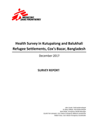
Survey report
Four health surveys were performed in Kutupalong Makeshift Settlment (KMS), Balukhali Makeshift Settlement (BMS), Kutupalong Makeshift Settlement Extension (KMS Extension) and Balukhali Makeshift Settlement Extension (BMS Extension). These sites were chosen to ensure that the health ...
Four health surveys were performed in Kutupalong Makeshift Settlment (KMS), Balukhali Makeshift Settlement (BMS), Kutupalong Makeshift Settlement Extension (KMS Extension) and Balukhali Makeshift Settlement Extension (BMS Extension). These sites were chosen to ensure that the health ...
WHO published the first COVID-19 Strategic Response and Preparedness Plan (SPRP) on 3 February, 2020. This report highlights the main points of progress that were made up to 30 June 2020 under the three objectives outlined in the SPRP: scaling up international coordination and support; scaling up co
...
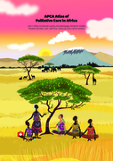
The APCA Atlas provides the most up-to-date information of palliative care development in nearly all countries in Africa, using indicators derived, rated, and chosen by in-country African experts followed by a thorough Delphi consensus process with a panel of international experts on palliative care
...
WHO recently conducted a survey to assess the availability and cost of a national tracer list of essential medicines in the outpatient sector in Ukraine using a new collection tool – the WHO Essential Medicines and Health Products Price and Availability Monitoring Mobile Application. This tool fac
...

This map illustrates satellite-detected, potential damaged structures in Muisne, Esmeraldas Province, Ecuador. The analyzed area is located approximately 30 km north of the 16 April 2016 Muisne earthquake mainshock epicenter. This analysis is carried out using Pléiades satellite image acquired 20 A
...
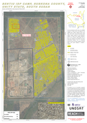
Analysis with WorldView-3 Data Acquired 07 March 2015
This map illustrates the IDP camp at the UNMISS Protection of Civilian (PoC) area adjacent to the UNMISS base in Bentiu, Rubkona County, Unity State, South Sudan. Using high-resolution optical satellite imagery collected by the WorldView-3 sat
...