Filter
27
Text search:
UNOSAT
Featured
Recommendations
4
New Publications
10
Language
Document type
No document type
19
Studies & Reports
3
Situation Updates
2
Strategic & Response Plan
2
Fact sheets
1
Countries / Regions
Haiti
3
South Sudan
3
Syria
2
Bangladesh
2
Mozambique
2
Uganda
1
Zimbabwe
1
Malawi
1
Ecuador
1
Myanmar / Burma
1
Asia
1
Africa
1
Global
1
Authors & Publishers
Publication Years
Category
Countries
9
Key Resources
7
Capacity Building
1
Public Health
1
Toolboxes
Natural Hazards
8
Conflict
5
Rapid Response
3
South Sudan
1
Refugee
1
Global Health Education
1
COVID-19
1
Planetary Health
1

This map illustrates satellite-detected, potential damaged structures in Muisne, Esmeraldas Province, Ecuador. The analyzed area is located approximately 30 km north of the 16 April 2016 Muisne earthquake mainshock epicenter. This analysis is carried out using Pléiades satellite image acquired 20 A
...
Analysis with WorldView-3 Data Acquired 07 March 2015
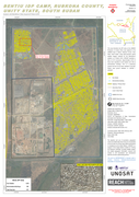
This map illustrates the IDP camp at the UNMISS Protection of Civilian (PoC) area adjacent to the UNMISS base in Bentiu, Rubkona County, Unity State, South Sudan. Using high-resolution optical satellite imagery collected by the WorldView-3 sat
...
Camps is intended to help address the absence of public and standardized training resources for those seeking to use high resolution satellite imagery in support of refugee/IDP assistance operations. Students, general audiences, and volunteers studying and analyzing satellite imagery of displaced po
...
This reference manual provides in-depth knowledge on the techniques, methodologies and best practices for using geospatial information in support of decision making for disaster risk management for specific hazards
Between 1992 and 2012, disasters caused more than 1.3 million deaths, affected more than 4.4 billion people and led to US$ 2 trillion in economic damages and losses around the world. This Disaster Risk Management Strategy explains how the Agency for Technical Cooperation and Development (ACTED) anti
...

Operational guidance for managing programme quality.
These guidelines are about implementing the programme-quality standards of the Core Humanitarian Standard in limited access humanitarian response. They have been developed using approaches and tools tested by Oxfam, other INGOs and the UN in Afgh
...
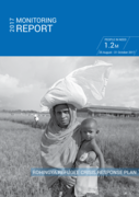
The Monitoring Report, which covers the first two months of the response from 25 August to 31 October, highlights the work of the Government of Bangladesh, in cooperation with humanitarian partners who are working to provide relief services for the refugee population and Bangladeshi host communities
...
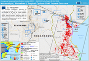
The European Commission allocated an emergency aid package of €3.5 million on 19/03. The funding will be used to provide logistical support to reach affected people, emergency shelter, hygiene, sanitation, and health care. Out of the aid package, based on needs, €2 million will be provided in Mo
...
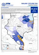
Since the beginning of March 2019, Malawi has experienced flooding and sustained heavy rain caused by the Tropical Cyclone Idai weather system. According to IOM Malawi, 81,613 households (HH) have been affected across four districts in the south of the country, specifically Chikwawa (12,755 HH), Zom
...
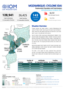
128,941 Total Individuals in Evacuation Centres
26,425 Total Families in Evacuation Centres
143 Evacuation Centres
36,747 Fully Damaged Houses
19,733 Partially Damaged Houses
The guide is designed to help disaster managers in national Governments gain basic knowledge of how to use international tools and services. It aims to support the growing disaster response and disaster response preparedness capabilities that exist at national level across Asia and the Pacific.
...
...
ACT Alliance appeal: Global Response to the COVID-19 Pandemic – ACT201 - Sub-Appeal - ACT 201-BGD -
The Atlas of health and climate is a product of this unique collaboration between the meteorological and public health communities. It provides sound scientific information on the connections between weather and climate and major health challenges. These range from diseases of poverty to emergencies
...
The Guide has been developed to enhance the knowledge capabilities of NDMAs and their local partners. This is accomplished by exposing them to the existing tools and services developed by the international community to facilitate effective disaster response to any scale of disaster (small, medium an
...